Tibetan Geography
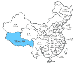
Since the 1950 annexation Tibet is a part of China. The borders of the country known as Tibet have been changing frequently throughout history. The lands inhabited by the ethnic Tibetans are shown on the map above. It covers a total area of nearly 2.5 million sq km (which is the size of Western Europe, or 5x the size of France)
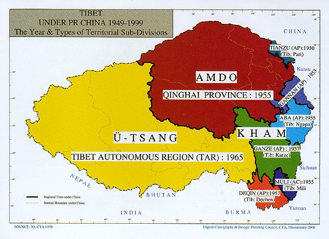
The truly independent state of Tibet, which existed between 1912 and 1950 had borders more or less identical with the current Tibet Autonomous Region (TAR) of the Peoples Republic of China. The area of TAR is approximately half of the historical/ethnic Tibet 1.2m sq km).
Historically Tibet was divided into 3 major regions:
- Kham in the East
- Ü-Tsang in the centre and the West
The map above shows dates whe the various parts of Tibet were incorporated into Chinese provinces. The Tibet Autonomous Region was created in 1965.
Lhasa is the capital and has around 200,000 inhabitants.Tibet borers the Chinese provinces of Qinghai, Gansu, Sichuan and Yunnan.
Today about 2.5m Tibetans live in TAR and about 2.9m in surrounding provinces.
Tibet is the highest plateau on earth ("Roof of the World") with the average altitude of 4,875m asl (16,000 ft). It is surrounded by three massive mountain chains: the Himalaya on the south, the Karakorum Range on the west, and the Kunlun Mountains on the north.Its highest peak is, naturally, Mount Everest.
Most of the biggest rivers in Asia have their sources in Tibet. The Brahmaputra (known in Tibet as the Yarlung Zangbo) is the mightiest river in Tibet. We'll be crossing it by ferry at the end of the trek. The crossing takes two hours!